Background
Basin Analysis Geographic Information System (BAGIS) was developed for use by the
National Water and
Climate Center (NWCC) at USDA,
Natural Resources Conservation Service (USDA-NRCS).
The NWCC is tasked with forecasting the water supply for the western United
States and generates essential information for
water resource managers. Water supply forecasting
requires the integration of accurate geospatial data and rigorous hydrological
models.
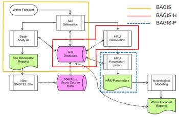
There are five major steps in creating a water forecast.
They are:
- Delineating areas of interest (AOI)
- Collecting precipitation data (via SNOTEL
or snow course sites) - Delineating hydrological response units (HRU)
- Summarizing HRU parameters
- Modeling hydrographs
Historically the
GIS Weasel has been used for completing steps one through
four. The PRMS system uses
data processed by the Weasel to generate the final models in step five. The
Weasel is an ESRI AML-based application developed on Arc/Info.
BAGIS can be used in place of the GIS Weasel to feed the PRMS system. In addition to Weasel functionality, BAGIS allows you to analyze and strategically locate Snotel and snow course data collection sites. BAGIS is built using updated ArcMap VBA and Add-In technology. There are three applications in the BAGIS suite of tools: BAGIS, BAGIS-H, and BAGIS-P. Use the menu at the top of this page to take a closer look at each.
BAGIS can be used in place of the GIS Weasel to feed the PRMS system. In addition to Weasel functionality, BAGIS allows you to analyze and strategically locate Snotel and snow course data collection sites. BAGIS is built using updated ArcMap VBA and Add-In technology. There are three applications in the BAGIS suite of tools: BAGIS, BAGIS-H, and BAGIS-P. Use the menu at the top of this page to take a closer look at each.